Friday, December 17, 2010

Milos West Coast
After two relatively easy days along the east and north coasts it was clear that the weather was on the turn. Early morning rain and strong winds hinted at more challenging kayaking conditions, particularly was we were heading out towards the more exposed west coast.
By 09.30 though conditions were more settled and we were able to take advantage of a lull in the wind to head across the entrance to Milos harbour towards Cape Vani.
Although the weather did deteriorate later in the day by then we were safely ashore but more importantly we were in a position that one more good day would mean that we should be able to complete the circumnavigation of Milos one day earlier than planned.
Approaching Cape Vani, the north west tip of the island. The cliffs are in this area are spectacular.
A brief stop was made at the old manganese mine just before Cape Vani. There were plenty of ruins to explore.
Manganese Mine. The first ore was extracted in 1898 and it is peak there were 250 people employed at the mine. In total 220,000 tones were extracted with the mine finally closing in 1928.
The beach at the mine was a rich source of driftwood which was going to come in really useful later in the day.
Chris and Shirley loaded with wood off the west coast of the island. The island behind is Antimilos, which is high on my list of places to paddle to.
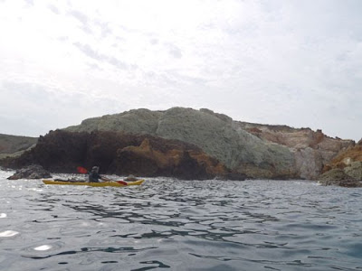
The complex geology of Milos creates a fascinating backdrop to the kayaking. Alternate bands of rock produce a colourful coastline. This is heading south along the west coast of Milos.
We had planned to reach the south west corner of the islands but a rapidly increasing wind forced an early finish at Agios Ioannis. This was fortunate as the wind increased in strength very quickly creating challenging kayaking conditions. We were ashore by this time.
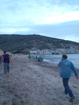
Happiness is a small tent on a Greek beach.
Strong gusts of winds blasting off the surrounding high land created problems for the tents despite to use of extra pegs and heavy stones. This is one tent being recovered from the sea.
When on a kayaking trip always try to take a chef with you. Gary was able to produce delicious meals for 30 people in no time at all. The driftwood from the manganese mine was particularly useful.
During a drop in the wind we were able to admire the sunset and monitor the build up of clouds to the west which hinted at the outbreak of thunderstorms.
Some of the locals! Fortunately the small building was open and we were able to find shelter during the worst of the thunderstorms.

Tuesday, December 14, 2010

Milos North Coast

Our second day dawned calm and warm with light winds enabling us to carry on kayaking from where we finished the day before. The distance today was quite short, only 10 nautical miles so there was plenty of time for playing and exploring the finer points of this intricate island.
We initially headed straight out to the Glaronisia Islands which were fantastic for jumping. From there it was a straightforward back to Milos before following the coast. The nature of kayaking here is directly linked to the geology of the area. The white volcanic ash, between Sarakiniko and Mandrakia is relatively easily eroded creating some stunning caves which were easily explored.
Our destination for the day was Plathiena beach which is close to the entrance to Milos harbour. On landing it was back to the hotel to pack because if we were to paddle along the west coast it was going to be necessary to spend at least one night out camping.

Jumping on the small offshore islets of Glaronisia. The name means seagull islands, as numerous pairs breed here during the spring. On this autumunal visit there were very birds in evidence. What there was though was some excellent jumping from above the arch. Basalt columns create a stunning backdrop to cliff jumping.
This ship ran aground off the north coast of the island on 7th December 2003, fortunately without the loss of life. It is interesting to note how it has deteriorated since I first visited the island several years ago.
Approaching Sarakiniko for more jumping. The stunning white rocks are probably the most photographed and well known location on the island.
The small natural harbour at Mandrakia. This is probably the Greece of tourist brochures, white washed buildings and blue seas. Our lunch was taken at the next small harbour at Firopotamos.
Trachilas Stacks are a fascinating place to explore by kayak. This was the only time that the group split during the whole circumnavigation of the island. Some people were eager to visit Arkradia Islands just offshore whereas others were happy to take the more direct route to Platiena where we were to finish for the day.

Monday, December 13, 2010

Milos Paddle

After a number of months training the time for the circumnavigation had arrived. A group who were essentially non -paddlers or sit on top paddlers had transformed themselves into competent sea kayakers.
The aim of the week was to circumnavigate this gem in the southern Cyclades of Greece. All the participants had been set the task of raising a certain amount of money for two local charities back home in Jersey.
The fund raising, in addition to the on-water training, had helped to create a cohesive group so it was with a certain amount of excitement and apprehension that we loaded the kayaks at Paleohori. Ahead lay nearly 50 nautical miles of memorable kayaking.
After about 30 hours traveling it was great to arrive on the island and some of us spent time leaping off the cliffs at Sarakiniko.
Leaving Paliohori on the morning of the first day. I was waiting to do a live broadcast on BBC Radio Jersey so had to remain on the beach for slightly longer than the rest of the team.
The south east coast is particularly memorable because of the variety of colours within the rocks.
The Sulphur Mine on the east coast of the island. In the past I have camped here several times but today it was a short visit for it was a mid-morning break only.
My two daughters, Lisa and Sarah, heading up the east coast. Kayaking is not high on their list of priorities but it was great to spend a few days on the water with them. The island behind is Polyaigos, a memorable island to paddle around.
As this is Milos, no description of kayaking here would be complete without reference to the numerous caves. This one on the east coast was easily able to hold 15 sea kayaks.
Mining is one of the principal industries of the island and there are several loading jetties scattered around Milos.
Due to the light winds we were able to paddle further than anticipated and at the end of the first day landed just to the west of Papafragas's cave on the north coast of the island. Kimolos is the island behind, which appears to be on fire, a superb paddle.
Ecrehous Buildings

Sometimes when we are kayaking we focus on the big picture and miss out on some of the smaller and at times more interesting items.
The Ecrehous, as many of you will be aware, is probably my favourite, all time sea kayaking day trip. Arriving at the reef, time is normally spent wandering around and admiring at the stunning seascapes whilst sitting on one of the finest benches in the world.
On the last couple of visits (including on Saturday) I have spent time looking at smaller features including inscriptions on some of the buildings. What has been revealed is fascinating history of a unique environment.

An aerial view of the islet of Marmotiere. There are 20 huts plus a number of smaller out buildings squeezed onto this small rock. La Petite Brecque is the other small islet with a hut built on. The shingle bank (La Taille) has a superb standing wave for surfing at high water on springs.
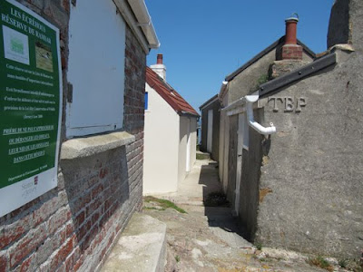
Looking towards the Impot Hut, which is painted white. It was probably built in about 1880. The initials "TBP" on the nearest hut refer to Thomas Blampied who probably restored the hut in the 1880's or 90's. This is one of the earliest huts to be built on the reef.
I had missed these letters on many previous visits to the reef. The letters refer to Josue Blampied, who was the son of Thomas Blampied who built the hut.
It is clear when this hut was built, at the time it was the largest building on the Ecrehous. In between St Martin and Jersey it appears some letters have been scratched out. It should read "St Martin. R.R.L. Jersey" The letters stand for Reginald Raoul Lempriere, who built the hut.

Sometimes we are so concerned with the big picture that we miss the detail so next time that you are out kayaking adjust the scale of your view and you never know what will be revealed.

Sunday, December 12, 2010

Greve de Lecq
One of the most popular bays in Jersey with both visitors and locals is Greve de Lecq, located on the north west of the island. It is also a firm favourite with local kayakers. The concentration of caves is second to none, many of them significant physical features.
We were fortunate today to have light easterly winds and no westerly swell so we were able to explore the caves with virtually no risk. As we paddled along the base of the cliffs there were a number of Fulmar's soaring on their stiffened wings, always a pleasure to see at this time of the year as they have returned to prospect their nesting sites.
A couple of hours exploration and we were ready to retire to the Moulin de Lecq for the Jersey Canoe Club Christmas lunch. A pleasant end to a Sunday morning paddle.
The coast to the east of Greve de Lecq is riddled with caves, some of which are surprisingly large. We managed to get 15 sea kayaks into one of the caves today.
This is the gap between Ile Agois and Col de la Rocque headland. The land on the left side of the photograph is actually at stack, Ile Agois. On the summit there are the remains of a number of stone huts, which is what remains of a 5th century Christian settlement.
Pete passing Devil's Hole, a significant feature along this stretch of coast. It is a huge blow hole and has been a tourist attraction for years. Unfortunately in these health and safety conscious times access to the bottom of the hole is no longer possible by foot. We were fortunate today to be able to paddle through the tunnel into the base of the blow hole. A Kingfisher flew past as we paddled this section of coast, always a pleasure to see when out on the sea.
Le Mourier Valley was our turning point. The small stream was certainly spectacular today.

Saturday, December 11, 2010

December at the Ecrehous

Located nearly 6 nautical miles north east of Jersey is a little bit of heaven known as the Ecrehous. In the summer months they attract numerous visitors from Jersey and France as well as further afield. On some visits I have seen in excess of 50 boats at anchor in the vicinity of the reef. Today though there were just two boats at anchor and Andy myself were the only people ashore.
The anti-cyclonic gloom didn't create a particularly photogenic day but it was great to get out on the water again and even better to visit this remote corner of the Baliwick of Jersey in December.
Sovereignty of the reef was granted to Jersey on the 17 November 1953 although the reef was "invaded" twice in the 1990's by Normans. The coast of France is just over 6 miles to the east. Over the last few years they have become more and more popular and it is a rare day indeed when you have the reef yourself.
Today was the 132nd time that I have kayaked to the reef over the years and I am as excited today when I approach the reef as I was when I first paddled here at the end of August 1974. In my view and in the view of many other experienced kayakers a trip to the Ecrehous is one of the finest one day paddles in the world.
All paddlers who visit Jersey should attempt to visit this fascinating archipelago.

Arriving off Marmotier at high water. The lack of a flag indicates the lack of residents.
Andy drifting backwards to play in the small race on the east of the reef. The coast of Normandy is visible behind.
This beach can really only be used for landing during the winter months.
The shingle bank, just after high water.
The classic Ecrehous view. In the summer months there would several boats visible.
Looking along the north coast of the island as we approach Jersey. The buildings are around the small harbour at Rozel and the closest headland is Tour de Rozel, possibly the best white water playspot on the island.

Friday, December 03, 2010

Warmer Times - Lihou

After numerous visits to Lihou, off the west coast of Guernsey, over the last few years this September's visit coincided with a period of relatively stable weather. Warm sunshine and light winds contributed to an excellent week on the island. A couple of us kayaked across the relatively narrow channel in perfect conditions.
The house is run by the Lihou Charitable Trust with their warden Richard Curtis. Popular with numerous groups it is important to book the island well in advance. If you are fortunate enough to stay there though you will quickly fall under the spell of this unique island.

The Jersey Canoe Club have a booking for the last weekend in June in 2011 on a neap tide, which is great because the causeway doesn't dry on neaps so we are guaranteed to have the island to ourselves. All 30 places went within a week, 8 months in advance which is evidence of the attraction of the island.
Looking across the channel from close to L'Eree headland. My first experience of flat calm conditions off Lihou.
Rachel getting ready to depart from L'Eree headland.
Lihou house sleeps up to 30 people and the conservatory has to be one of the finest places to drink morning coffee in the Channel Islands.
Part of the old Priory. Founded in the 12th Century, it was linked to Mont St Michel in northern Brittany.
Off for a evening paddle
Due its location off the west coast of Guernsey, Lihou is exposed to the Atlantic swell. Here a slightly larger swell breaks in the channel between Lihou and Lihoumel.

Thursday, December 02, 2010

Jersey from a different perspective

A number of reasons have combined to prevent the up dating of the blog as much as I had hoped for but these images of the south west cliffs of Jersey have encouraged me to put a few pictures on the site.
Jersey has a stunning landscape but the arrival of snow, which is very rare, transforms the island into something truly memorable.
Schools were closed today so we made the most of the unexpected bonus. All we need to do now is to get out on the water.


Looking east from near Corbiere, the north easterly wind hadn't picked up yet.
Nicky on the the headland at Landes du Ouest. This was early in the morning and we were the first to head out onto the cliffs. Corbiere Lighthouse is visible behind.
Petit Port in the south west of the island. The high tide mark is clearly visible in the snow.
The snow continued to fall throughout the day and this is looking north along St Ouens Bay late in the afternoon. Better know for its surf the beach was a very special place today.

Wednesday, September 15, 2010

Morbihan
It had been 12 months since our last visit, which was probably too long. Morbihan (which means “Little Sea” in Breton) has to be one of the great paddling areas of Europe. Don’t expect dramatic scenery and a wilderness experience though. This is a popular tourist and sailing venue but the combination of world class historical sites, tidal streams reaching 8 knots, a diverse bird population and usually pleasant weather conditions produce a fascinating kayaking area.
The entrance to the Golfe de Morbihan. A knowledge of buoyage is vital here because of the numerous craft which navigate the waters and the speed at which they travel.

The small fishing boat was closing pretty quickly upon us, even though the GPS was registering nearly 8 knots and we were barely paddling. The narrowing of the channel to the south of Iles Berder and Gavrinis forced the stream to accelerate as it rushed towards the open sea, still nearly 2 miles away. We were taking advantage of this liquid conveyor belt but clearly the fisherman had other ideas about both our sanity and paddling ability. The raised, shaking fist and the shouts that we were stupid and likely to die did little to improve the confidence of the more hesitant members of the group.
History from the water. The stone circle at Er Lannic at low water, as the tide rises it is possible paddle between the stones. Just to the north, across the fast moving tidal stream is Gavrinis, the world famous passage grave, is visible in the trees.
We were on the final rush towards the open sea at the end of two days of superb paddling. Although the tidal streams do run fast in the Gulf, with appropriate planning it is possible to harness that power to your own advantage and so enjoy a relatively effort free ride around the inner recesses of the Gulf. Although many people are put off by stories regarding the power of the tidal runs do not be unduly apprehensive. Try to arrange your first visit to coincide with neaps, use a detailed chart and be sure of your position at all times.
Saturday was a leisurely exploration of the islands close to Larmor-Baden. One ferry glide after another allowed us to access golden sandy beaches, narrow inlets and historical sites. To me the most fascinating location is the semi-submerged stone circle of Er Lannic, due to sea level rise the circle is largely submerged at high water, where else is it possible to paddle through megalithic monuments? As the afternoon progressed we jumped onto the ebbing tide and hitched a free ride back to Locmariaquer.
Locmariaquer at dawn. A great place to base yourself for the weekend or longer.