Tuesday, February 28, 2012

Sea Kayaking Books

I have spent some time producing a comprehensive list of the sea kayaking, and other paddling books, which are in my collection and so it is interesting to consider which books I would recommend to people who are interested in the development of our sport.  This is my selection of 5 books which I consider to be essential reading.  Please feel free to disagree and suggest alternatives:

Sea Canoeing by Derek Hutchinson 1976: For me this was a book that inspired a generation of paddlers and it was one of the first titles which was specifically about the aspects of canoeing and kayaking that I was interested in.  Derek is recognized by many as the father of modern sea kayaking due to his ground breaking trips and kayak designs.  This book gave me information on navigation, surfing etc.  There have been many more books published since but this was the first of its type.
The Dreamtime Voyage by Paul Caffyn 1994:  This is the definitive expedition book.  I had read all of Paul Caffyn's previous books and although they described significant achievements none of them grabbed the readers like the circumnavigation of Australia.  It is testimony to one of the finest sea kayaking achievements of all time.
Argonauts of the Western Isles by Robin Lloyd-Jones 1989: This book could almost have been written by anyone of us, if we were accomplished authors.  It is adventures in local waters, sea kayaking off the west coast of Scotland with friends.  The book was updated several years ago and is still a worthy read.
 Water and Sky by Alan Kesselheim 1989: This follows the journey along the Athabsca by Kessleheim and his wife.  Sub-titled "Reflections of a Northern Year" the writing captures the hardships and delights of living in the far north.  In addition the conflicts between the modern world and traditional native communities are examined.  This is a delightful book which goes far beyond the paddling.
Sea Kayaking by John Dowd 1981:  This was quite a controversial book in the UK when it was published due to some of the more extreme comments.  I bought my copy at a Crystal Palace Canoe Exhibition in the early 1980's and quickly went through the book from cover to cover several times.  There was so much in here that wasn't in Derek's book, they complemented each other nicely.  It has been updated several times, I think that I have all the editions, but I still like dipping into the first one.


It is surprising how many sea kayaking books are now available, it is just a matter of deciding which are the more interesting, informative etc.

Monday, February 27, 2012

Morbihan Revisited Part 2

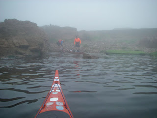
We awoke on the second day to thick fog.  Everything which had seemed so clear the day before was shrouded in mystery.  As we departed the beach, compass bearings, the GPS and acute hearing were the order of the day.  Morbihan at times can be one of the busiest areas of water that you will paddle in.  Numerous small ferries linking the various ports and more leisure craft that you can imagine.
As we crossed over the entrance the fog started to disperse as the rising sun worked its magic.  Within 20 minutes of starting to paddle we had seen 3 other groups of paddlers, testimony to the popularity of the area for sea kayaking.  We used the southern branch of the tidal stream to carry us into the eastern sections of the Gulf.  Running through gaps with the GPS registering over 7 knots meant that some members of the group were relieved that were only on neaps.  On a large spring tide the flows between the islands can be truly awesome.
The bird life in the area is amazingly diverse and varies from season to season.  The summer birds were clearly in the ascendancy, the cries of numerous terns pierced the air and Shelduck were visible around most of the islands.  What we were really interested in were the Ibis, which now reside in the Gulf, but we were to be disappointed.  We headed towards Ile Govihan, were we had seen them before but today the perches which had been occupied by Ibis previously, were now supporting cormorants.  Slightly disappointed on the ornithological front, we turned north in beautiful sunshine and steered towards Ile IIur.  The west facing beach was the lunch spot and it allowed us to explore the small settlement on the island, including its beautiful chapel.
The return journey was around the northern edge of the Gulf, passing close to Ile D’Arz and Ile aux Moines.  There were a number of superb old sailing ships which were visiting the Gulf as part of a maritime week which was due to start the following day.  One of the interesting things about paddling in Morbihan is how the tidal streams suddenly change from negligible to extremely fast in a short space of time.  As we passed the southern end of Ile Berder the water flow increased to about 6 knots and we enjoyed a fast ride towards the entrance of the Gulf.  Although the water was quite confused it was important to keep away from the eddies along the edge where violent boils could throw the kayaks around at will.  The problem with the main channel is the sheer number of other craft, one French fisherman in particular shaking his fist and exclaiming that we were all going to die.   Clearly he had less confidence in the kayaks than we did!
As we approached the entrance to the Gulf the tidal streams continued to assist our journey.  It was important to plan several moves ahead though, at one point we were moving sideways at over 6 knots.  As the narrows of the entrance were cleared, the force of the tide quickly dissipated and we were able to ease our way back to the south facing beach from where we had left 6 hours previously.
The Golfe du Morbihan  is a fascinating sea kayaking destination and when combined with paddling in a couple of the other Breton regions it would make an ideal venue for a weeks holiday.  The combination of tidal streams, historical traditions and Breton hospitality will ensure a thoroughly enjoyable visit!
 Looking from Gavrinis towards the entrance to the Gulf
 Due to the nature of the region there is always somewhere sheltered to pull up for lunch.  This particular day we selected Ile Ilur.
 The area has a rich maritime tradition which is maintained to the present day.  Paddling around Morbihan there is usually a variety of sailing craft to observe.
 
 A number of the vessels have not stood the test of time and in some of the more sheltered inlets it is possible to encounter ships which are a shadow of their former glory.
 Morbihan is a great place for developing white water skills.  Nicky is playing on some small tidal rapids off the south west corner of Ile aux Moines.
 The overall memory of paddling in Morbihan is of fast moving tidal streams, in certain areas, set against a rich historical backdrop and diverse wildlife. 

Sunday, February 26, 2012

Stand Up PaddleBoard Race

Quite a thriving community of stand up paddleboarders is developing in Jersey and every two weeks, to coincide with high water on a spring tide, a race is held at St Brelade's.  It is essentially three lap[s of a course, out and around a pole, followed by a short run on the beach.  For many today the highlight was the small dolphin which was playing in between some of the boards.
It is a highly social activity with friends and family able to watch and support and those who are interested play on the boards afterwards.  There are usually a range of boards available from both Naish and Starboard who are the major suppliers of SUP in Jersey.  The next race is in two weeks time and fingers crossed that I do rather better than my pretty dismal performance today.
14 racers disappearing over the horizon!  There is a pole just to the left of the pier which it is necessary to go around.  Each race consists of 3 laps.  On the first lap some of the paddlers were accompanied by a rather inquistive, young dolphin, which appears to have been in the bay for a couple of days.
At the end of each lap it is necessary to leave the board and complete a short run, so the edge of the water is always busy with both paddlers arriving and departing.
It was just a short run around the flags but after 3 laps the legs were beginning to feel it.

Morbihan Revisited

It had been 12 months since our last visit, which was probably too long.  Morbihan (which means “Little Sea” in Breton) has to be one of the great paddling areas of Europe.  Don’t expect dramatic scenery and a wilderness experience though.  This is a popular tourist and sailing venue but the combination of world class historical sites, tidal streams reaching 8 knots, a diverse bird population and usually pleasant weather conditions produce a fascinating kayaking area.
The small fishing boat was closing pretty quickly upon us, even though the GPS was registering nearly 8 knots and we were barely paddling.  The narrowing of the channel to the south of Iles Berder and Gavrinis forced the stream to accelerate as it rushed towards the open sea, still nearly 2 miles away.  We were taking advantage of this liquid conveyor belt but clearly the fisherman had other ideas about both our sanity and paddling ability.  The raised, shaking fist and the shouts that we were stupid and likely to die did little to improve the confidence of the more hesitant members of the group.
We were on the final rush towards the open sea at the end of two days of superb paddling.  Although the tidal streams do run fast in the Gulf, with appropriate planning it is possible to harness that power to your own advantage and so enjoy a relatively effort free ride around the inner recesses of the Gulf.  Although many people are put off by stories regarding the power of the tidal runs do not be unduly apprehensive.  Try to arrange your first visit to coincide with neaps, use a detailed chart and be sure of your position at all times.  
Saturday was a leisurely exploration of the islands close to Larmor-Baden.  One ferry glide after another allowed us to access golden sandy beaches, narrow inlets and historical sites.  To me the most fascinating location is the semi-submerged stone circle of Er Lannic, due to sea level rise the circle is largely submerged at high water, where else is it possible to paddle through megalithic monuments?  As the afternoon progressed we jumped onto the ebbing tide and hitched a free ride back to Locmariaquer.
Locmariaquer at dawn.  We had just popped out for croissants, but the sun rise promised a geat day on the water.  This small town, close to the western entrance to the Gulf, is an ideal base for a few days sea kayaking.
Er Lannic, a semi submerged stone circle.  Landing is not possible because this is now a bird reserve but it is an inspirational place to kayak past.  These stones are estimated to be 5,000 years old and have been affected by rising sea levels.  Just to the north tidal streams run in excess of 9 knots!
 
 Gavrinis dominates much of this area of Morbihan but the island is famous because of its important passage grave from the Neolithic era. When it was constructed, c. 3500 BC, the island was still connected to the mainland. Inside the tomb there are some stunning decorated slabs which means that it is one of the most important sites in Europe.  Unfortunately access is only possible using the tour boats from Lamor-Baden.
 
Lamor-Baden viewed from the south.
 
 A typical Morbihan scene.  Most of the land visible in the photograph is on islands.  It is a complex area where accurate navigation is important.
One of the numerous navigation marks in the area, it is important to know your buoyage.  Port Navalo is to the east but we were turning west to land on the small beach we had left a few hours earlier.

This posting was first published in May 2008.

Friday, February 24, 2012

A Foggy Inconvenience

One of the downsides of living on an island is that sometimes we are inconvenienced due to factors which are completely outside our control.  Today in Jersey and all over the UK thousands of travelers, who are hoping to get to or from the Channel Islands, are affected by that old adversary of the sea kayaker, Advection Fog.  
The warm air which has been bathing certain areas of Britain in warm sunshine has resulted has resulted in travel chaos in Jersey.  No flights have landed in Jersey for over 48 hours and apart from a few flights when the aircraft were in position there have been no departing flights since Wednesday. 
This evening I should have been on my way to Barcelona, with my daughters, to run in the half marathon on Sunday morning, as it is I think we will have to go paddling in Jersey this weekend.  
Do not underestimate the impact of Advection Fog.
 Not a sign of Corbiere
 Looking back towards the German tower.  Contrast this view with the ones taken on Monday.
This is view north towards St Ouens, below is the view that it should have seen.

Plage Bonaparte

In between St Quay Portrieux and Paimpol, in the Baie de St Brieuc, are found the tallest cliffs in Brittany at Plouha.  To the north lies L’Anse Cochat also known as “Plage Bonaparte”, which on initial viewing looks like a pretty beach and that is all.  In fact though this is not the case, as it is the site of some of the most memorable events of the Second World War, in this area.  Between January and August 1944 135 American and Canadian airmen who had been shot down over occupied France escaped to England with the assistance of the French resistance.  
In 1943 two French Canadians, Lucien Dumais and Raymond Labrosse arrived in the area to help co-ordinate the rescue of the airmen who had been shot down.  They were grouped in a house known as Maison d’Alphonse, which was eventually blown up by the Germans in July 1944, before being led across the Breton countryside to the beach where small boats were used to ferry them to British ships, which were waiting offshore.  The first escape was on 28th January 1944 when 18 airmen made it back to England from Brittany.   
Today as you paddle along the coast it would be easy to dismiss the broad sweep as just another beautiful Breton beach without being aware of the history of this short stretch of coast.   We had launched from the delightful small harbour at Port Moguer and were on a day trip to L’Ost Pic, a distinctive lighthouse to the north.  
On the early morning high water there was no beach showing but on the return on the afternoon low water there was a beautiful sandy beach with gentle surf rolling in.  With the bright February sunshine it was hard to imagine the events of 63 years earlier.
 Approaching Plage Bonaparte on the morning high water.
 
 Agnes just in front of the valley down to the beach.
 Approaching the small village of Brehec, our chosen lunch spot.
It always amazes me how pleasant picnics can be in Brittany, even during February.
This stretch of coast, to the south of L'Ost Pic is similar to so many stretches of the Breton coastline.  It is possible to feel quite isolated soon after launching, particularly during the winter months.
 When L'Ost Pic lighthouse was built, in 1894, it was the first lighthouse in France to have a couple appointed as the keepers.  In common with so many lighthouses in Brittany it was partially destroyed in 1944 but by 1948 it had been restored to its previous condition.
By the time we returned to our departure point the sun had moved into the south west making viewing difficult but the tide had also dropped exposing the sands across which so many allied airmen had escaped in the early months of 1944.

Thursday, February 23, 2012

Roches Douvres

25 nautical miles west of Corbiere lies the the reef of the Roches Douvres.  On clear nights, the white flash every 5 seconds, is visible on the horizon and it had long been an ambition to paddle out there.  It was the only part of "Channel Island" waters which I had never visited by sea kayak.  It is a long way to go though with obvious escape routes, so ideal conditions and confident partners are required.   So when tides and weather seemed to combine to make a visit possible Chris, JR and myself started planning.  It was less than 48 hours from conception to departure.
The Roches Douvres was first lit on 15th December 1868 although construction wasn't completed until August 1869.  For over 70 years it helped protected mariners operating in the area but the top of the light was blown off by the retreating Germans in August 1944.  Reconstruction wasn't completed until 1954, so my understanding is that it was the last major lighthouse to be completed in France.
It was automated in 2000, so we had the reef to ourselves on a perfect June evening.  We settled down for an enjoyable bivi prior to an early start the following morning for the return crossing to Jersey.

 Approaching the Roche Douvres in near perfect conditions.  We felt very isolated at this point.  The lighthouse is reputed to be the light which is furthest offshore from mainland Europe.  The north Brittany coast was 15 nm to the south.
 Three original Nordkapps.  Two HM's and one HS.  Classic kayaks in magnificent surroundings.
There wasn't much to explore on the reef, but we did climb to the top of the old helicopter landing pad to get a mobile phone signal.  It was French, phoning home required an international call.
We prepared for the bivi in almost perfect conditions.
We had woken to clear skies but conditions were deteriorating rapidly.  It didn't matter how fast we packed, things weren't going to improve for quite a few hours.
Visibility had dropped significantly in less than 30 minutes.  The top of the tower, at 197 feet above sea level, was fast disappearing.
I was afloat first and it quickly became apparent how limited the visibility was.  It was obvious that it wasn't going to be a relaxing 25 nm crossing.
Visibility was very limited for the first 4 hours.  All we saw was an ice cream container and a dead cormorant.  At least it meant we could continue to focus on the GPS.  For at least the first hour Ile de Brehat, in France was closer, then for the next hour it was the Hanois, off Guernsey which was closer.  Eventually Corbiere became the closest way point.  We at least felt that we were on the homeward stretch
Due to the poor visibility we called into Jersey Radio (later changed to Jersey Coast Guard) to inform of our position and to ask for advice regarding the shipping in the area.  It was a relief when they called up later to request our position as there was a Condor fast ferry in the area.  By this time the visibility had started to improve but it was still a relief to see it pass by.
A welcome sight.  Corbiere Lighthouse our final destination after over 5 hours of paddling.  As we had managed to maintain a good pace we were back in Jersey in time for lunch and a pint at the Corbiere Phare restuarant and bar.

This paddle was first put on the blog in June 2007.

Wednesday, February 22, 2012

Kayak Sculpture

I came across this "interesting" sculpture whilst in Oslo for a Leonard Cohen concert.  I can't imagine the authorities at Jersey Harbours, placing an item of sculpture depicting kayaking, in St Helier harbour.  Nice to see that Art and kayaking can co-exist happily in a public place.

As many regular readers might remember in September 2011 I had the site hacked into, by somebody living in France, who proceeded to delete everything that I had produced since 2005 when I launched the blog.  I managed to recover a number of the postings but lost nearly 5 years work. 
What I am going to do, is bit by bit, try and put a number of those posts back on the site over the next few weeks if possible, mainly because in those 5 missing years we went to some pretty interesting places.

Tuesday, February 21, 2012

Tonight's Sunset

It was such a stunning evening it seemed a pity not to stop and take a few photographs of one of the most scenic locations in the Channel Islands, whilst on the way home from work.

 Evening the German fortifications looked good in the setting sun.  This tower is available for rental if you plan far enough in advance.  For many years it was the location of Jersey Radio, which became the Coast Guard and moved to St Helier Harbour.
 Corbiere Lighthouse is probably the most photographed location in Jersey.  Even on a Tuesday evening in February there was a line of photographers attempting to capture the mood of the scene.  Built in 1874 it was the first lighthouse in the British Isles to be built entirely of concrete.
 On Easter Monday 1995 the French vessel, the Saint Malo, with 307 passengers on board struck a rock just north of Corbiere.  This memorial was erected in 1997 to commemorate the fact that no lives were lost that day.
Behind Corbiere the next landfall is Newfoundland.  So many great kayaking memories in this area starting off in the 1960's and continuing right up to the present day.  Just a great view to have on the drive home from work.

Jersey Towers Part Three

As we continue our journey by kayak around the coastal waters of Jersey there are number which we encounter on a more regular basis.  Fliquet Tower is probably the closest to the Jersey Canoe Club premises although we probably paddle past Archirondel more frequently.  Three of the towers are on offshore islets, the two shown here plus Seymour Tower, off the south east corner.
In the late 18th and early 19th century the island was clearly under threat of invasion by French forces and the authorities took this threat seriously as demonstrated by the number of towers which still exist around Jersey but they do add another dimension to our paddling.

The tower at Fliquet is seen regularly by members of the Jersey Canoe Club, who pass by regularly on their summer evening paddles.  The tower looks unusual because the top fortifications have been removed.  It is one of the oldest towers and was in existence before 1787.
In the centre of Portelet lies the small island, Ile au Guerdain.  On its summit is the tower which is known locally as Janvrin's Tomb, this is due to the death of Philippe Janvrin, the captain of the vessel, the Esther, from the plague.  The authorities refused to allow the body to be brought ashore and so the crew buried his body on this small island, within sight of his home.  The grave has long been replaced by the Tower which was built in 1808 to help protect the island from Napoleonic forces.

Another tower which is situated offshore is Icho Tower, built in 1810 to help protect the south coast.  For the paddling bird watcher this is a particularly productive region during the winter months, with a wide range of species.
Victoria Tower, built in 1837 was the last one to be built in the 19th century.  It is unique amongst Jersey towers because it has a moat and a drawbridge.  Behind is St Catherine's Breakwater, the home of the Jersey Canoe Club.
Looking south from the top of Mont Orgueil Castle across the Royal Bay of Grouville.  This area was particularly vulnerable to attack from French forces so within this bay alone there were six towers plus two Forts.

One of the most enjoyable aspects of sea kayaking in Jersey is the historical background to the paddles.  The Jersey Towers are just one aspect to the rich and varied history of this small island.