Belcroute always feels reasonably isolated although after a cliff fall in 1930 evidence was discovered which indicated that the area had been inhabited since the Iron Age. Today it always feels a bit isolated although it is relatively close to St Aubins whilst the buildings of St Helier are clearly visible across the bay.
It has been used as a deep water anchorage for many hundreds of years, although it is relatively close to St Aubin, which from around 1700 was the main harbour on the Island. The wealth of the village was as a result of the trans Atlantic trade, particularly the cod fishing industry of Newfoundland. The merchants in the area grew rich and built numerous substantial properties, which are known as cod houses.
Although parking is limited at Belcroute I have never had a problem finding somewhere to leave the car as it doesn't get particularly busy. As an East facing beach it is well sheltered from the prevailing wind but the steep land behind the beach means that the sun is lost early in the day. Access to the beach is via a short but relatively steep slipway, at high water the beach is pebbles but as the tide drops sand is exposed.
Belcroute was used as the quarantine anchorage and in 1721 the Esther with her captain Philippe Janvrin, returned to the Island from Nantes, where there was an outbreak of the plague. On the second of anchoring in the bay Janvrin died, his body was not allowed to be brought ashore and so he was buried, by 3 of his crew, on a small island in Portelet Bay, Ile au Guerdain, whilst the burial service was read out from the coast overlooking the bay.
The tower in the middle of the bay is known as Janvrin's Tomb, although it is i fact a Martello Tower built in 1808. There whereabouts on Janvrin's body is not known, although it has been said that it was removed to St Brelade's churchyard, there is no evidence of this.
With today's forecast Belcroute was the inevitable choice, and we weren't disappointed.

Many of the slipways around the island were built in the 19th century, not necessarily for boat access but to allow horse and carts onto the beach to collect the seaweed which was used a fertilizer. The edges of the granite blocks are offset so that horses hooves got a better grip.

Steff heading out from Belcroute. St Aubins Fort is visible behind.
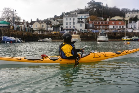
Into St Aubin's Harbour. The white building directly above Pete's head is the Old Court House. Now a pub and restaurant it featured in Bergerac in the 1980's. It is thought that the building may have been used by the Privateers to divide the goods they had captured from the French.

St Aubin's Harbour is one of the most photogenic on the Island. The large building is St Brelade's Parish Hall, although it used to be the Railway Station.

Tracey heading towards La Haule. La Neuve Route is the road running along the seafront, which was built on reclaimed land in 1844, before then it was necessary to head up La Haule Hill and the come into St Aubin's Village via the High Street.

St Aubin's Fort dates from the 1540's but its present appearance is probably from 1840, although the Germans enhanced the fortifications during the Second World War.

There was some small surf coming into the bay so we had an enjoyable 30 minutes olaing in the waves.

There was a bit of bright sunshine as we came past the Fort with the view enhanced by the hundreds of wading birds, particularly dunlin, in the area.
No comments:
Post a Comment