Monday, September 26, 2011

Herm Again

Herm has to be one of my favourite Channel Islands and it holds many attractions for the sea kayaker.  Just a couple of miles off the east coast of Guernsey but separated by significant tidal flows it is always an entertaining paddle.  These are just a selection of the photographs taken on my three visits so far this year.

 
When crossing the Little Russel from Guernsey it is worth keeping an eye open for some of the other maritime traffic.  Guernsey does attract some large vessels such as the Queen Elizabeth.  Just north of the ship is the location of the tidal diamond described in an earlier post.
Heading along the north coast of the island in delightful conditions.  The Humps are stretching away to the north, great sea kayaking but out thoughts were focused elsewhere this particular day.
On the small hill known as Le Petit Monceau is a statue by Antony Gormley.  It appeared in March 2010 and is visible from some distance away when approaching the island.
 Another piece of art work has appeared close to the harbour, greeting the thousands of visitors to the island.  By Ev Meynell, this 5 metre tall piece, is called "In Flight"
 For most sea kayakers the main attraction of Herm is the quality of the paddling.  Here we are heading south along the famous Shell Beach.  A memorable day.
Looking up the east coast.  Belvoir Bay is the first beach with Shell Beach slightly further away. 

Sunday, September 25, 2011

Spring Tides This Week

This week sees some of the largest tides of the year, with significant amounts of water moving around the island.  Wednesday in particular promises to be pretty entertaining for both the casual observer and sea kayaker.
The basic facts are as follows:
High Water:  19.57  39.3 feet  12 metres
Low Water:   02.45   1.7 feet  0.5 metres
This translates to a tidal range of 37.6 feet or 11.5 metres, which is pretty substantial.
Using the 12ths rule this means that in the 3rd and 4th hours of the tidal sequence there is 1.89 inches of vertical movement every minute for the whole two hours, the water will just be flowing up the beach with not inconsiderable speed, an amazing sight to see.
I am certain that many locals will be heading out low water fishing but I am sure that a number of sea kayakers, myself included will be heading for the tidal races, particularly Tour de Rozel.
 High water at St Brelade's Bay, it is normally possible to walk to the pier along the beach.  In some places off the south east corner of the island at low water the sea will have retreated nearly 2 miles, exposing a unique littoral environment.
If there is any swell there is the potential for significant flooding along the south coast and at St Ouens, fortunately Magic Seaweed is predicting 2 feet or less of swell for Monday.
What there will be plenty of opportunity for is playing in the tidal races, particularly off the north coast.  Light winds and high temperatures can only enhance the paddling possibilities.


Saturday, September 24, 2011

Ecrehous Day Trip  
It was clear as the week progressed that high pressure would be building for the weekend and conditions would be ideal for a day trip to the Ecrehous, the only issue was that nobody seemed to be available for the paddle.
It was too good a day to miss though so I headed out on my own.  A quick radio call to Jersey Coastguard and I settled into a steady pace.  It was interesting to note an almost complete absence of birds whilst paddling just a few gannets and an inquisitive cormorant were my only companions on the crossing.  Arriving at the reef I expected to be greeted by numerous boats which had crossed from both Jersey and Normandy but it was surprisingly quiet.  Just a few on the moorings and a couple more fishing the outer edges of the reef.
The light southerly wind which had aided my journey out died away completely whilst having an early lunch so the return paddle was in quite exceptional conditions for a couple of days after the autumn equinox.
Sea kayaking is a social activity but sometimes a few hours on the water on your own, focuses your thoughts, ensures that you have confidence in your own navigation and provides the opportunity paddle in your own rhythm without always having to refer to other members of the group.
 
Looking back towards the north coast of Jersey.  These were the only boats moored at the reef apart from a couple of French yachts.  In complete contrast to the last visit hen upwards of 60 boats were at the reef.
The Jersey flag flying over the reef indicated that people were in residence.
Some of the small houses.  The faint outline of the French coast is just visible.
The French side of the shingle bank, my kayak is just visible close to the rocks.  Its a much shorter carry landing on this side of the reef.
Looking north along the tombolo.  Great surfing waves develop across the pebbles at high water on spring tides.
I first visited the Ecrehous by kayak in 1974 and despite numerous visits I can never remember bumping into other Jersey paddlers.
Heading back to Jersey I paddled around the north of the reef before heading towards the Petite Rousse.  The tide was heading south with considerable speed, I reached more than 8 knots on several occasions.
The north coast of Jersey is just visible beyond the Petite and Grande Rousse.  The 5 nautical miles passed in less than an hour.
Leaving the Ecrehous, one of the great sea kayaking day trips.

Thursday, September 08, 2011

The Paternosters

For many sea kayakers their first open crossing can be quite a daunting prospecting, cutting the tie with the shore and heading away from the security of the land requires a different approach to when you are just paddling parallel to the shore.
For many Jersey sea paddlers their first visit offshore is to the Paternosters reef which is nearly 3 miles off the north coast of Jersey.  3 miles isn't that far but when combined with cross tides up to 5 knots an the exposure to the Atlantic swell it becomes a bit more challenging than your average paddle.
At high water landing can be a problem, if not impossible, if there is any swell but as the tide drops a number of sheltered lagoons are uncovered which allow access to the reef.
I first paddled to the Paternosters in early 1979 and every year since I have visited on a number of occasions but have never encountered any other people on the reef, it really is the ideal place to get away from the crowds in Jersey.

Peter Wrigglesworth arriving at the Paternoster's after a crossing from Greve de Lecq.  The rock is gneiss, a metamorphosed granite which isn't found anywhere else in Jersey.

 One of the great aspects of the Paternosters is that it is the site of one of the best jumps in the Channel Islands.  John Richardson and myself are taking full advantage of the warm water.
 A few sea kayaks on the reef on a bitterly cold January day.  There was ice on the beach when we left and it was still there when we arrived back a few hours later.
 At low water rocks and boulders are uncovered with a few isolated sheltered lagoons.  At high water just a few isolated heads are exposed generally catching the full force of the North Atlantic swell.
 Looking back towards the north west corner of Jersey.  The island looks like distant in these conditions.
 Heading south towards Greve de Lecq, on sunny days it is always difficult to identify specific locations due to the angle of the sun.

Wednesday, September 07, 2011

South East Towers

The south east corner of Jersey is a unique marine environment which is frequently referred to as Jersey's  last wilderness.  The sea retreats with amazing speed, particularly on spring tides, creating a fascinating sea kayaking playground.  Swift tidal streams swirl around the isolated heads whilst numerous birds feed in the area.
Green Island is an ideal departure point as the tide floods, assisting the passage out to Icho Tower, which was flat calm on the day as opposed to previous visits when the westerly swell was breaking heavily on the surrounding reefs. 
The tidal assistance was even more beneficial as we carried on towards La Conchiere, a navigation beacon which has been upgraded over the last 12 months.  Pottering around the reefs is always entertaining and today it was followed by lunch on the platform in front of Seymour Tower, which gives an unusual perspective of the south and east coasts.
The temptation to linger is always strong, but as the tide dropped it was necessary to jump onto the tidal streams to avoid a long carry back at Green Island.  Mis-timing your arrival in this area could be really inconvenient!  A seal appeared on several occasions on the way back, they are not that common in Jersey waters so are always a pleasure to see.  
What is great about this paddle is that it can be completed in a couple of hours at any time of the year, a delightful way to explore Jersey's last wilderness.
 Icho Tower is the more westerly of the two towers, built slightly later than Seymour Tower, in response to Napoleonic threats
 La Conchiere Beacon was the most southerly point on the paddle, several miles offshore.  On large spring tides the foreshore dries this far out.  The familiar bent navigation pole which has survived for years was replaced this year with the south cardinal mark.
 Jersey looks along way off when at the Conchiere.
 On the way to Seymour Tower we passed another of the navigation marks in this area, Karame, easily identified by its top mark.
 It was possible to land on the sand bank close to Seymour Tower.  On a spring tide it would have disappeared and so landing would have been much more problematic.
Built as a result of the French invasion of Jersey in 1781, Seymour Tower is one of the classic landmarks off the south coast.  Now managed by Jersey Heritage it is a great place to spend a night.
The inevitable photograph of the kayak on the beach.  Looking towards Gorey and the east coast of the Island.

Tuesday, September 06, 2011

Les Hanois Lighthouse

This year I have been fortunate enough to visit the Hanois Reef, with its distinctive lighthouse, twice.  On following days but in contrasting weather conditions.  On the Saturday, low cloud, drizzle and steady force 5 from the south west created interesting kayaking conditions.
By the following morning the wind had dropped, the sun had come out, it was a different world
Les Hanois is built on a reef off the south west corner of Guernsey, protecting generations of seafarers from the hazardous conditions which are found in this area.
From the early 19th century it was felt that a lighthouse was needed in this area but it wasn't until early 1860 that the first stone arrived on the Island.  Cornish granite was taken to Castle Cornet, at St Peter Port, where it was worked on by craftsmen from Cornwall before being transported around Guernsey by barge.
The work was frequently interrupted by poor weather conniptions and if that was the case the builders who were living in Fort Grey, helped to build the Trinity House Cottages on the way to Pleinmont.  The light was lit for the first time on the 8th December 1862.
I remember on bleak October day in the early 1980's running and Advanced Sea Course in the area.  we left from Rocquaine Bay, with fresh milk and the papers, which were the calling card of sea kayakers in those days.  A little gift almost invariably resulted in being invited in.  Our excitement for the day was being allowed to climb out onto the helipad.  Added in 1979 it is 33 metres above the sea and standing on it, with the sea breaking over the reef below, was one of the most terrifying things that I have ever done.
Those hospitable days are long past though as the light was automated in 1996. That said any sea kayaker who is visiting Guernsey should plan to visit the Hanois, its a great couple of hours.
Looking out towards the Hanois from Pleinmont headland.  On a day when sea conditions were relatively calm.

Just off the Hanois in June this year, in conditions more reminiscent of the autumn than early summer.

Heading back towards Lihou after failing to land.  Not all of us made it back to the island upright!
Approaching the Hanois on the second day.  Conditions had improved significantly although landing was still a challenge.
It is only when looking up the lighthouse that the true beauty of the construction can be appreciated.
Although it was much calmer the easiest way to land was to swim in whilst leaving the kayaks in the care of somebody offshore.  Lihou island is just visible through the rocks behind the kayaker furthest left.
John Richardson enjoy the benefits of a salt water bath.

A visit to Les Hanois is always memorable so I am hoping for good weather next week when I am on Lihou with a school group for the week and should be able to get in a visit to the reef if conditions allow.
Positive Thoughts

On Sunday morning I updated the site before noticing that all of the posts of the last 6 years had disappeared.  After a little help from Peter in Australia I managed to locate a number of the posts and managed to re-instate a number of the pages.  This was extremely frustrating to say the least but things took a slightly more frustrating turn when with a bit of investigative analysis I discovered that the site had been accessed from France and somebody had maliciously deleted all my work of the the last few years.
What is interesting that it was possible to find out how they had discovered the site, where they live (within a radius of a couple of kilometres) and the unique identification of their computer, plus some other bits and pieces.
It is sad to think that some people have nothing better to on Saturday nights than spend time trying to destroy other peoples work and what a waste of talent.
This is a site about sea kayaking though and so here are a few pictures to remind us why we go paddling rather than spending our time trying to destroy other peoples work.  Family, friends and the environment.
 Chester at Tour de Rozel
 The family having circumnavigated Milos
 Katie in a storm bound Uags bothy
 The Ecrehous in June, where is better?
 Disko Bay, Greenland
Jersey Canoe Club trip around Herm.

Sunday, September 04, 2011

Another Project

 
I have spent over 40 years sea kayaking in Channel Island waters, mainly around Jersey but I have visited all of the other islands on numerous occasions and this book contains much of the information that I have gained over the years.
It is more that a paddling guide it includes plenty of historical and geographical information.
It has been published for the Kindle and is available as a download from Amazon.  It contains well over one hundred photographs and 45,000 words for not much more than the cost of a magazine.  That is one advantage of ebooks, in that it is possible to keep the costs down.
It is possible to download Kindle apps for PC's, Mac's, iPads, iPhones, Androids etc with the added advantage that the photographs will appear in colour.
So if you are a local paddler or thinking about heading towards the Channel Islands then it could prove a useful companion.

Ios or Santorini

After a windy night we woke to a much calmer morning. The kayaks were quickly packed and we were ready for an early start to Ios. The plan was to cross the channel and head down the west coast before camping at the southern tip, prior to crossing to Santorini the following day. We thought that it was going to be a relatively short day.
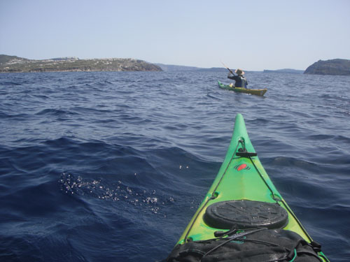
Half way to Ios, in what was much better weather conditions, than we could have imagined the night before, we checked the distance of the direct crossing to Santorini, which was clearly visible to the south. 18 nautical miles was the direct distance, a quick discussion, a few stronger left hand sweep strokes and the bows of the kayaks were pointing south.
We settled into a rhythm and within a few hours we were coming ashore on the beaches just on the outside of the caldera for a late and much needed lunch.
We are all familiar with the images of Santorini but no amount of photographs can do justice to scale of the caldera. It is a truly astonishing natural feature. As we entered from the north it was difficult to imagine the impact that the volcanic eruption must have had on civilizations in the eastern Mediterranean. It really is one of the wonders of the natural world.
Through some rapid calculations using data from the GPS and an opportune weather window we had arrived on Santorini a day early and we were looking forward to exploring this world famous destination.

We headed towards Ios with a light northerly wind on our beam. The crossing should have taken just over an hour.
I have always enjoyed using a GPS and it really came into its own today. Ios, our destination, was 4 miles away but Santorini was clearly visible on the horizon. A quick change of Waypoint indicated that it was only 18 miles to Santorini, with the light northerly breeze helping it would be 5 hours at the most.
Visibility was excellent on the crossing, the snow covered mountains of Crete were visible to the south west but our main focus was on the cliffs of Santorini, which were becoming much clearer as we approached.
Pete and John having a well earned lunch break at the first opportunity on Santorini. We had been in the kayaks for over 5 hours when we landed.
Paddling into the remains of the caldera, the full scale of Santorini can be appreciated. The classic view is of white houses perched on top of volcanic cliffs.

The inside of the caldera is huge. Its quite easy to lose si
ght of cruise ships!
There can be few places in the world which are so instantly awe inspiring.
We made the effort to walk up to the rim of the caldera, in search of food and stunning views. We were not disappointed with either but it was strange to see so many other people after effectively being on our own for over 3 days.
The classic Santorini sunset. The distant islands were on our route of the previous few days.
Camp sites were not easy to come by. Having pitched the tent for some peace and quiet I ended up sharing my terrace with a snoring dog. Not ideal preparation for the following days planned kayaking around the inside of the caldera.