Sunday, October 05, 2014

A Bonne Nuit Sunday

Bonne Nuit was the venue for today's sea kayaking with Jersey Canoe Club.  It is always an issue which way to head, to the east lies Belle Hougue, with its entertaining tide race whilst the coast to the west has a number of interesting physical features.  Today felt like a day for geography so we headed west in the bright October sunshine.
 One of the convenient aspects of paddling from Bonne Nuit is that even at low tide it is a pretty short carry.
 A rather faded plaque on the habour wall was unveiled by Chay Blyth in 1991 to commemorate the 25th running of the Sark to Jersey rowing race.  This annual fixture in Jersey's sporting calendar finishes at Bonne Nuit.
 Although the cliffs aren't totally vertical the slopes are steep providing a spectacular backdrop to the kayaking.
 There are plenty of small channels to explore but the swell was arriving in sets, at times catching people unaware.
 A quick swim was followed by the emptying out offshore.
 Rock type certainly influences scenery.  The dark rock to the left is part of the St John Rhyolite formation whilst the red of the granite is clearly visible to the right.
 Approaching to workings of Ronez Quarry.  The old pier structures are to the right.  Ships no longer weave their way through the offshore rocks to collect their cargo of stone.
 John paddling close to the rocks off Sorel headland, the most northerly point of Jersey.
 Jim approaching Le Mourier Valley.  An isolated section of the north coast.
 Looking into Devil's Hole.  Although a tourist attraction on the north coast, very few people see it from this perspective.
 Heading back towards Bonne Nuit.  Belle Hougue is in the distance but we will be turning right just past the first headland to return to Bonne Nuit.  With SE Force 7-8 forecast for later it was an opportunity grasped.

Wednesday, October 01, 2014

Guensey's South Coast

Following Brian's epic swim to the Hanois we headed east towards Pleinmont Point, to meet the south coast of Guernsey and head towards St Peter Port.  The south coast of the island is spectacular and continuous.  There are very few places with easy access to the sea , so there is always a feeling of commitment when kayaking in this area.  
After a gap of a few years of paddling in this area it is pretty satisfying to have completed the south coast paddle twice in just over 8 weeks.  It is probably 2015 before another opportunity will occur.
 Arriving at the south coast, having crossed from the Hanois Lighthouse we reached the coast just to the west of L'Angle Tower.  Constructed by the German's it is one of the most impressive range finding towers in the Channel Islands and is unusual that it is rectangular as opposed to be round.
There is nearly always some interesting geology to be seen.
La Prevote Tower is another large fortification along this section of the coast.
 Just leaving Petit Pot after a quick lunch break.  This is probably the only place along the south coast where there is relatively easy access with a car, although parking is not always easy.  The tower is one of 15 which were built around Guernsey between August 1778 and March 1779, as a defence against possible French invasion.
 Approaching Icart Point
 
 Approaching the Pea Stacks, close to the south west corner of the island.  These are dissected by a number of channels and the height of the tide was ideal for exploration by kayak.  They were painted by Renoir in the summer of 1883, when he visited Guernsey.
 
 Heading through the channel between the Pea Stacks and the mainland.  The tidal flow, which was in our favour is just visible.
 Conditions remained ideal as we headed towards St Peter Port.  Just after taking this photograph we were graced with an encounter with some dolphins.  In contrast to the bottle nose dolphins that I have seen on many occasions off Jersey these were Risso's Dolphins.

Tuesday, September 30, 2014

Herm again

The plan had been to paddle across to Herm for an evening at the beer festival but the prospect of a north easterly F6 blowing against one of the largest tides of the year required a strategic re-think.  Get the ferry from St Peter Port.  This was a decision that was completely justified when we saw the size some of the areas of overfalls.
The beer festival was great event with some interesting music from local band Buffalo Huddlestone, I had not really come across Guernsey rap music before!  The following morning allowed us time to explore this delightful Island before heading to Guernsey on the ferry.  The only downside was that this time we didn't get to paddle across but conditions on the Wednesday were just a bit too entertaining.
 This is probably the most iconic view on Herm, Shell Beach but although I have been numerous times over the years I can't actually remember seeing the beach at high water on a spring tide.  It came as a bit of a surprise.
Many of the visitors to the island will follow the coastal path with the result that you miss out on some pretty good scenery and the opportunity to interact with some of the locals.

The common occupies the northern part of the Island.  Sir Percival Perry, who was chairman of the Ford Motor Company, was tenant of Herm prior to the Second World War.  He converted part of the common into a golf course.
The recently restored harbour crane is now on display in front of the White House Hotel.  It was dismantled in 1997 and shipped to Guernsey where it was stored until recently.  Built in approximately 1850 it was used to load Herm granite onto ships.  The rock was used in the construction of Blackfriars Bridge in London as well as the East and West India Dock Walls.  When time allows I should go through my slide collection to find pictures of the crane in use in the 1970's and 80's.
The south west of Herm, I have spent many a happy hour paddling these waters.
The Herm shopping parade built in the early 1960's by a group of Italian workmen.  It always surprises me that when I visit I can find something to buy.
Looking south along the west coast of Herm.  A ferry is alongside the small jetty, which is almost submerged because of the height of the tide.  Behind lies Jethou, which was once the home of Compton MacKenzie, best known for his book "Whiskey Galore".  To the left lies La Grande Fauconniere and to the right Crevichon.
The small island of Crevichon, which lies just to the north of Jethou, is passed quite close by when heading from Herm back towards Guernsey.  As can be seen from the profile there has been a history of quarrying on the island with the granite being used in the building of Castle Cornet in St Peter Port and possibly the steps of St Paul's Cathedral in London.
 Sitting in the middle of the Little Russel and surrounding by some truly amazing tidal streams, is Brehon Tower.  Completed in 1856 the tower was no longer needed by the First World although it was used by the German's in the Second World War.  Today it is the home of a small tern colony.  behind and to the right of the tower are the chimney's at St Sampson, which are an ideal navigation mark.

Monday, September 29, 2014

Another Ecrehous Day

The continuing spell of settled meant that the Ecrehous was an ideal destination for Sunday's sea kayaking adventures.  The relatively large tide, just over 35 feet meant that a prompt departure from St Catherine's so that we avoid the fastest tidal flows.  The crossing of just over 5 nautical miles was completed in a very satisfactory 1 hour 10 minutes.
On spring tides the water often flows across the tombolo, which joins Marmotiere to the smaller islets to the north.  It is always a great place to play and Andy obliged with swimming through the run so I could experiment with the various options for rescuing a swimmer.
Although it was the last weekend of September and the continuous flow of swallows south was an indication that summer was over,  the temperature rose into the low 20's celsius. A very pleasant few hours were spent on the reef before heading back to Jersey, and again the crossing passed relatively quickly.  Isn't it satisfying when the navigation works out?
Although we will no doubt visit this far flung corner of the Baliwick of Jersey over the coming months I think it will be some time before we have such pleasant conditions.


 Andy playing on the small race which develops over the tombolo, when we first arrived.
 In places the water is shallow, fast and clear.  It can be very disorientating if you spend too much time looking down.
 Just after high water on a spring tide.  There is not much of Marmotiere showing, within a couple of hours a totally new landscape will be revealed.
Transporting Andy to shore after he swam through the race for the second time.  This was a far more stable position than having him on the rear deck.
 Once the tide drops it was time to explore the northern part of the reef on foot.  A couple of hours earlier this is the spot we had been surfing.
 One of the small alleyways which thread their way through the small but well kept huts on the main island.
Kate demonstrating the advantage of a plastic kayak when it comes to launching.
 Re-grouping at the southern end of Maitre Ile before starting the crossing back to Jersey.

Tuesday, September 09, 2014

A day on Lihou

Every day on Lihou is special but today was particularly so.  Sea kayaking in the morning, swimming and fishing in the afternoon and walking in the evening.
 Leaving the south side of Lihou in the morning, heading for the cafe at Portelet.  Lihou was part of the first designated RAMSAR sites in Guernsey.
 Happy paddlers with full stomachs heading back to the kayaks.  Lihou is the large island on the horizon.
 Heading north back to Lihou
 Lihou Priory was in existence by 1156, today it lies in ruins.
 The stones always look particularly warm in the late evening sunshine.
 The remains of the dove cot, part of the food source for the Priory
 The view south towards Pleinmont headland.  The Hanois light is just out of the picture to the right.
 Watching the tidal stream pour north through the gap between Lihou and Lihoumel.  3 hours earlier we had be able to scramble across the gap.  At this point we were people furthest west in the Channel Islands.
 Heading back towards the house for evening meal.

A swim to the Hanois

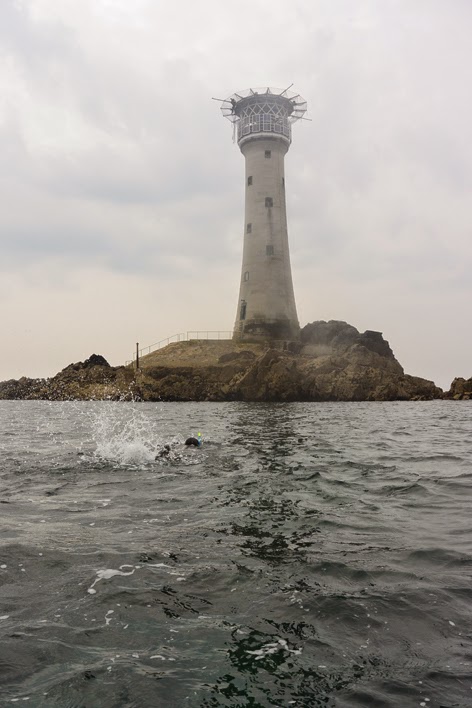
Off the south west corner of Guernsey is one of the classic lighthouses, the Hanois. We paddled out to the light in June this year, but sitting at Cobo last Saturday evening Brian Aplin explained that he had planned to swim from Lihou, out to the Hanois the following morning.  The aim was to use the southerly tidal stream to speed things along although care was needed not to be swept past the reef.
Launching from the causeway across to Lihou was probably the most challenging part of the day, the tide was dropping at quite a rate.  We joined up with Brian off the north west corner of Lihoumel and very quickly felt the impact of the tide.  Accelerating through the reefs but heading towards the Lighthouse.
Brian swam with just a couple of breaks to take on extra liquids.  On my GPS I measured the course as 2.18 nautical miles, taking him 1 hour 40 minutes to cover the distance.
I towed Brian's Nordkapp but when we arrived at the lighthouse there wasn't an easy option for him because we paddled a further 12 miles to St Peter Port.
 Joining up with Brian off the north west corner of Lihou.  He is just to the left of the closest rock.  The Hanois is barely visible in the distance.
Well under way.  Lihou is the large island on the horizon.  Brian swam in his crocs, they seemed ideal for this type of activity
 At this point I thought there was a possibility of missing the reef as the tide was pushing us south fairly quickly.  With the benefit of knowing how to ferry glide when swimming Brian did achieve the shelter of the reef.
 Almost there.  As far as we know nobody else has completed this remarkable swim.  What  a way to spend a Sunday morning.