Saturday, August 09, 2014

How far have I paddled?

Over the years I have come in for some ridicule as I have kept a kayaking log book. My first entry was in January 1979 and since that date I have made a record of every time that I have been in a canoe or a kayak.  Sometimes it might just be a brief note whilst at other times it might be a comprehensive record of where we parked the car, what the launch was like, any wildlife seen etc.  Due to the fact that I have kept the log book going for so long it has now become almost impossible to stop.
Earlier this year I was wondering to myself as to whether I paddled the equivalent of the circumference of the earth at the equator?  First of all how far is it around the equator.  Plenty of places will give you the distance in kilometres and statute miles, it was only after a bit of searching that I found the answer in nautical miles, it is 21639nm.  My log book records have always been in nautical miles so this was an important figure to find.
I then sat down with the log books and over a couple of hours completed a table. There were 5 columns, standing for year, sea kayak, sit on top, canoe/general purpose and total.  I passed the magical distance on the 19th May 2012 whilst on a trip out to the Paternosters.
So if you don't already keep a log book think about starting keeping a record of your paddling experiences, in a few years time it will make interesting reading.  I don't have a log book from 1969 to 1979 sadly, as there could be some interesting reading about a number of sea kayaking adventures, including being pulled of the water by Tito's police in the former Yugoslavia, as we naively thought it was alright to paddle on the sea in communist countries.

 The oldest picture I have scanned in.  The first trip to the Ecrehous, August Bank Holiday Sunday 1974.  Is it really 40 years since I first paddled out to the Ecrehous.  Possibly the best one day paddle anywhere.  This was probably the first ever organized paddle by the Jersey Canoe Club, which we had just formed.  This was 5 years before I started keeping a log book but it was a pretty memorable day.
A few months after I started keeping a log book.  An evening surf session in May 1979 at St Brelade's.  We were so proud of our KW7's.  So versatile, one day we would be rock hopping the next heading out to an offshore reef.

 One advantage of keeping a log book is that you are able to track your memorable paddles.  This is dawn on the morning of my 150th paddle to the Ecrehous, we are packing away before returning to Jersey.
The day that I passed the equivalent of the circumnavigation of the earth.  Getting ready to leave the Paternosters.

Thursday, August 07, 2014

Ecrehous Day Trip

The neap tide, today, meant that timing for departure wasn't as crucial on some other days but we were still on the water promptly just before 09.30.  The Ecrehous is one of the great, if not the greatest, one day sea kayaking trip.  
Just over 5 nautical miles north east of Jersey it is necessary to allow for tidal drift as on springs the tidal streams can reach over 5 knots but as you start to enter the reef it soon becomes apparent that you have arrived somewhere really special.
Today was no different.  If you are ever in Jersey with a sea kayak, a visit to this special place should be high on your list of priorities.
 
The view across the pool towards Jersey, it wasn't as busy as on some other summer days.  Whilst sitting on the bench having lunch a grey seal spent some time swimming around in the water below us.
Looking north across the reef.  In a few hours time all of the rocks would be submerged by the rising tide, next Tuesday would be even more interesting as the tides are so much larger.   Today's high water was 27.9 feet, in 5 days time it is 39.6 feet!
Looking along the shingle bank its hard to believe that on Spring's standing waves develop as the tide runs across the bank.
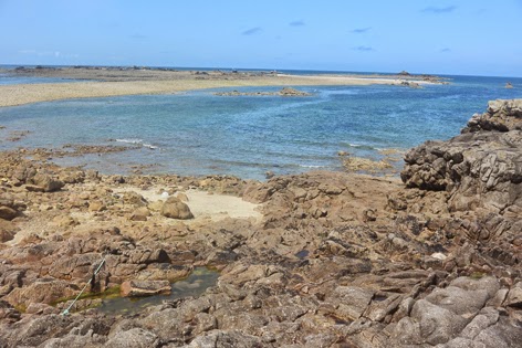
If time allows when visiting the Ecrehous it is always worth walking north, partly to escape the crowds but more importantly to view the dramatic seascape.
 Looking across towards the Normandy peninsula of France.  The clouds defined the edge of the land.
 Nicky paddling past one of the huts as we paddled north to catch the last of the south flowing flood tide.
 The edge of the reef, it was right hand sweep strokes to line up for a 5 mile crossing.
 Visibility was pretty good today so Jersey was clearly visible as soon as we left the Ecrehous. After about 1 nautical mile we had several groups of bottle nose dolphins pass in front.  They seemed pretty focused on heading west so they didn't stay and investigate.

Wednesday, August 06, 2014

Thoughts of better days

So our bags never made it to Karlstad, we returned to Stockholm Airport on Monday morning and found them within 30 seconds of entering the baggage hall.  Joining the others on the river was not easy, it was going to take nearly 36 hours, so we decided to fly home. Gutted that we missed out on the opportunity to spend 7 days on a Swedish river with other members of the Jersey Canoe Club.
After a day of sitting around moping about missed paddling opportunities there are a couple of bright spots.  Firstly, my first attempt at producing a book about a sea kayaking trip arrived from Blurb.  It was an easy process to go through and the result is a special reminder of a lovely week away.  So much better than having thousands of digital images sitting on a hard drive, which are rarely looked at.  I am certainly going to produce a few more books of some of the paddling trips we have been on over the last couple of years.
The second highlight is a trip to the Ecrehous tomorrow, one of the great sea kayaking destinations, half way between Jersey and France.
The Gozo book cover. 

Les Ecrehous.  Tomorrows destination.

Sunday, August 03, 2014

Travel misery

By now we should have been well on our way down our Swedish river as we were due to be undertaking a 7 day canoe trip with some other members of the Jersey Canoe Club.   The first hint of a problem was landing at Stockholm Airport and I received a text to say that my luggage hadn't arrived.  Actually we were 3 bags missing, mine and Nicky's main bags and John's small one.
The agent at the airport seemed pretty confident that the bags were on the next flight and that they would be delivered to us by the following morning at the latest, this now seems like a ploy to get rid us from the airport.
So confidently we boarded the train into Stockholm and onwards to Karlstad feeling confident that we would be re-united with precious equipment by the following morning, how naive.
Saturday morning dawned sunny and warm but no luggage, we headed to the bus station but were unable to contact the baggage handlers until 09.00 when they opened, it seems like they will loose luggage 24 hours a day but only offer a restricted service when trying to find it.
After a 20 minute hold on a phone call from my mobile I finally got through to an agent who reliably informed me that 2 bags had already arrived and the 3rd was due on an aircraft just before 12.00.  Happy days but we needed somewhere to stay as it was going to take about 4 hours to transfer to Karlstad.  The other 5 members of the group had now headed north on the bus and we were hoping to be able to catch up later.
Then at 10.30 I received a text to say that my bag was on a flight arriving at 14.55, this meant that we were going to miss the last bus north so quickly find a hotel.  It just happens that the Swedish 14 year old football championships are being held in Karlstad so rooms were at a premium.  We eventually managed to book the last room, in a rather nice hotel and decided to head off on a boat tour around the city.
Just after 16.00 I called the baggage handlers convinced that the bags would be heading our way and we would be heading north to join the others on Sunday morning.  To my utter dismay I was told that they thought 1 bag had arrived, but were still awaiting confirmation, and they were still trying to locate the other 2.  Clearly we were going nowhere fast.
Sunday morning dawned to thunderstorms and at 09.00 I managed to contact the baggage handlers after being on hold for 10 minutes to be told it would be 2 hours before they could confirm if any bags had arrived.  You can only take so much so we checked out of the hotel and headed to the railway station to go back to Stockholm Airport and see if we could collect any bags at all.  We arrived at the station 45 minutes before the train to Stockholm and when we tried to purchase tickets all trains to Stockholm are sold out today.
Therefore we retreated to a very nice coffee shop, thank you "Expresso House, Karlstad".  After 30 minutes of being on hold as the recorded message from Menzies Aviation, Sweden told me that one of their agents would be with me shortly, I hung up.  Clearly "shortly" has a different meaning in the world of Menzies Aviation as it does in the rest of the English speaking world.
So as I sit in Karlstad in the coffee shop and I cannot believe that it is so difficult for a bag to get from Heathrow to Sweden.  A ruined canoeing trip and frustration with the wonders of modern technology.

Thursday, July 31, 2014

Gozo South Coast

As a break from the usual watery wanderings around the Channel Islands I thought I would cover a trip that I was fortunate enough to do a couple of weeks ago.  It was along part of the south coast of Gozo, Malta's northern and smaller neighbour. 
What Gozo and Jersey have in common is a sheltered coast, when the wind picks up.  On this particular day we were experiencing a north westerly force 6, so not ideal for two of the coasts of Gozo.
The obvious route was out from Mgarr Ix Xini, a narrow inlet, which several centuries ago provided a sheltered anchorage for galleys.  Today it is a popular location for diving, one of the mainstays of the Gozo economy.
The entrance to the bay is marked by a tower, which was built in 1661, from there we headed east along the coast, enjoying scenery which isn't as dramatic as elsewhere on the island but still entertaining.  
Our destination was Hondoq, a popular launching spot for kayakers, but where we were going to have lunch and take advantage of the cafe before returning to Mgarr Ix Xini.  This isn't a particularly long day trip but it is a recommended option when the wind is blowing out of the north.

Launching from Mgarr Ix Xini.  The sign warning of the nature of the slip was needed, several of the group fell over.
Heading out of the bay
From offshore the entrance to the inlet isn't easily seen, although the tower, which is just out of the picture is a bit of a give away.
 An old military institution, which is being re-developed for residential purposes, Fort Chambray, overlooks the channel between Gozo and Comino.  During the Crimean War the Fort housed 500 British troops.  It has also seen service as a Leprosy Hospital
 There were a number of caves along this section of coast, which are worth exploring.  The land behind is the island of Comino, a great day trip from Gozo.
 Our destination for lunch was Hondoq, with its popular cafe, which serves possibly the best banoffee ice cream anywhere.
 There were a number of offshore rocks to explore.  These are just outside the harbour at Mgarr, which is Gozo's main link to the outside world.
 In several places the authorities have thoughtfully placed some jumping platforms.  What a contrast to Jersey where the authorities seem intent on banning jumping into the sea.
The tower protecting the entrance into Mgarr Ix Xini, built in 1661.
Back where we started from and an opportunity to swim in the crystal clear water.

Wednesday, July 30, 2014

Sark to Jersey

After a superb day and evening on Sark it was time to head home.  A memorable meal on the terrace of Stock's Hotel followed by an evening in the Mermaid Disco is something not to be missed.
It was a relatively early start as The Tower Hamlets Canoe Club members had flights to catch back to London and most of the Jersey paddlers had work on the Monday morning.
We chose an earlier departure time than normal and what a good decision.  The first two hours were relatively straight forward as we headed towards the Paternosters, although Brittany Ferries did pass a bit closer than I was happy with, paranoia from earlier crossings in my kayaking career.  Just to the north of the Paternosters we switched to a more south westerly track to take advantage of the tide, which helped push us along at over 6 knots.
Landfall in Jersey was just under 3 hours for the 12 mile open crossing and then we spent a bit of time was dawdling along one of the most spectacular sections of the Jersey coastline before landing at Stinky Bay.
A quick beer at the Watersplash was followed by a dash to the airport for our London paddling friends.  A delightful weekend.
 There are some things which make you realize that you are in Sark, including the size of the bank.
 The Avenue.  This is the main shopping centre in Sark.
 The Tower Hamlets Canoe Club members prior to departure.  What a great weekend to choose to come over from England.  Channel Island sea kayaking at its best.
 Just leaving Dixcart Bay looking along the east coast of Sark.
 
 Sark gradually starts to fall away.  We had left from Dixcart Bay, on the left of the photograph where the boats are anchored.
 Brittany Ferries from St Malo to Portsmouth did pass fairly close by, but its appearance out of the haze did help with our forward paddling speed!
 Landfall was between Grosnez Castle and Les Landes bunkers.  When we turned near the Paternosters, to take advantage of the tide, our speed increased to over 6 knots.
 Although we had been aware that there was a slight swell running as we crossed from Sark, it wasn't until we started to head through some of the reefs that we became aware of its impact.
 Just heading south past the Pinacle, one of Jersey's most distinctive physical features.
 Toby coming into Stinky Bay, a well named landing spot.  The decomposing sea weed, clung to our legs, clothes and kayaks with amazing tenacity.  Not the best place to land but a memorable arrival after a memorable few days.

Tuesday, July 29, 2014

Circumnavigation of Sark

Sark is one of the truly special sea kayaking destinations and this weekend we were fortunate enough to be able to complete a circumnavigation of the island in all almost perfect conditions.  Parts of the island have been covered in an earlier post in relation to Mervyn Peake and Sark but there is a lot more to the island.
We launched from Dixcart Bay, a convenient bay on the east coast, which provides relatively easy access to the main facilities on the Island, via a wooded valley.  The circumnavigation was clockwise meaning that we headed south first. Unusually there was very little swell so we were able to wander through the reefs and channels off the southern tip with relative ease.
Possibly the most challenging, but also most rewarding, part of the circumnavigation is the area around the Gouilot Passage.  To the west lies the privately owned island of Brecqhou, whilst to the east are the Gouilot Caves, through which the tide runs at quite a considerable pace.  The ability to perform a hanging draw, in the semi darkness, is a vital skill in this area.
To the north lie a variety of coastal erosion features such as the arch at Port au Moulin and the stacks at Les Autlets, interspersed with a huge number of caves, the presence of which were document by the Latrobe brothers in the early 20th century, a copy of their book is essential research for anybody exploring the coastline of Sark, by whatever means.
Bec du Nez the most northerly point of the island was missed as it was possible to cut through a channel to the south of the headland.  Heading south along the east coast we passed underneath Point Robert lighthouse before reaching Maseline Harbour.  This was completed in 1948 and was designed to take larger vessels than the original harbour at Creux, in the hope of increasing the number of visitors.
Creux Harbour lies just to the south of Maseline and was the original harbour.  It was destroyed in the winter storms of 1865/66 so the present jetty dates back to 1868.  We popped in for a quick visit, noticing the rack of sit on tops belonging to Adventure Sark, a specialist outdoor provider based on the Island.
From here we threaded our way through some very narrow passages before arriving at Derrible Bay, the Creux, a distinctive geographical feature is at the back of the bay and a must visit location, particularly if the tide is in.
Dixcart Bay is next, our starting point 8 miles earlier.  A memorable 3 hours of sea kayaking behind us. 
In the evening as we walked from the restaurant back to the campsite there was an intensity to the darkness which you don't get in many places, which is why the island was awarded Dark Sky Status. The clarity and number of stars was quite exceptional.  Just another reason to visit this sea kayaking heaven located about 12 miles north of Jersey.
 The view south from Dixcart Bay.  L'Etac is the island offshore, that is the usual landfall when crossing from Jersey.
 
 Paddling through the cave, just to the north of La Coupee, the narrow bridge of land which joins Sark to Little Sark.
Moie de Breniere, off the south east coast of the island
The whole of the coastline is pretty rugged, with easy access to the water only possible in a few places.
 Heading towards the Gouliot Passage.  Brecqhou is the island to the left.  The tides run up to 8 knots in this area.
 Looking across La Grande Greve towards La Coupee.
Entering the Gouliot Caves, the tide was running north through the caves, with a speed which created some interesting conditions.
Looking across the Gouliot Passage towards Brecqhou.
Toby sitting under the arch at Port au Moulin.
Paddling through Les Autlets
 Creux Harbour on the east coast was the original harbour for the island.
Looking out from the northern tunnel in the Creux de Derrible.  The conclusion of the circumnavigation is only another few hundred metres.

Friday, July 25, 2014

Baja final day

We were due to be picked up, just after lunch, at Punta Coyote, which meant that we could have a pretty easy morning.  As it was we were still away at the usual time of just gone 08.00.  It's pretty difficult to have a lie in with these temperatures.
As it was a relatively short distance we had time to stop a couple of times and relax before our pick up. Gradually preparing ourselves for a more structured way of life.
Baja is a truly special place and although there are plans for developments in certain areas it is still possible to find solitude when traveling through the area by sea kayak.  Living in Europe it can seem that the logistics of visiting the area are pretty challenging, which at times they can be but the reality is that the experience is well worth the effort.  Start planning your winter sea kayaking trip now.
 Although we had the luxury of a late start we were still up before sunrise.  This has to be one of my favourite times of the day.  The island is Isla San Francisco, which we visited the day before.
 Heading south past the stripped cliffs.
 
 We had plenty of time so we pulled ashore on this long beach which was backed by some fairly tall sand dunes.
 We had plenty of time to explore the surrounding area, some of the cactus were surprisingly tall.
 Kate studying the remains of a turtle we discovered on the beach.
 Back in La Paz it was time celebrate another great trip in Baja.