Today was the day when we would be entering the most exposed section of kayaking that we would undertake on the whole trip. As we rounded the western end of the Nuussuaq Peninsula the nearest land would be Baffin Island about 250 nautical miles to the west, the nearest land to the north and south was considerably further away.
I had seen this area once before, from 36,000 feet on my way to Seattle and even in the winter the currents appeared to keep certain sections of the sea free from ice.
I had seen this area once before, from 36,000 feet on my way to Seattle and even in the winter the currents appeared to keep certain sections of the sea free from ice.
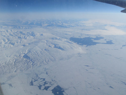
The western end of the Nuussuaq Peninsula seen from 36,000 feet courtesy of British Airways. Note the open water possibly the result of stronger tidal flows.
True to form we paddled the first 5 or 6 hours against the tide, but as we approached the western point the summits of the coastal mountains started to appear through the mist as the fog banks retreated offshore. There were some seriously large pieces of ice which were eroding into spectacular shapes but the actual rounding of the point proved to be relatively stress free although looking at the beaches and items on the shore it was clearly an area which experiences significantly large waves.
Once around the point, Disko Island came into view and we felt that we had possible completed the crux of the paddle. We had covered 25 nautical miles but it hadn't seemed unduly tiring.
Our campsite had superb views over the entrance to the Vaigat, our route into Disko Bay, the only slightly disconcerting thing was whilst on an evening stroll we camp across a rather large print in the sand. There was either somebody walking around the beach wearing crampons or there was possibly a bear in the area. As we hadn't seen any other people I went for the second option with the belief that it was an old print! Whatever it was we didn't find out but I did wake rather more frequently during the night.


Andy in the fog, somewhere fairly close there some very large bergs

Approaching the western tip. Note the yellow navigation mark above and to the left of the bow of the kayak.

The fog had dispersed. It is views like this which draw us back to Greenland time after time.

Although it was the end of July in a few places there were still some patches of snow at sea level

Nicky with a spectacular lava flow.
 The backdrop to the camp site was pretty special.
 The tipi is a great piece of group kit. Although it is ideal in poor weather it really comes into its own when it is calm and the insects are active.
 Is this a polar bear print? Not that clear but enough of it was visible to cause us some concerns.
 Nicky, in the late evening light, looking across the Vaigat towards Disko Island.


No comments:
Post a Comment